Nature conservation efforts at Brackenridge Estate form part of the activities of various bodies and institutions that are aimed at preserving and enhancing the natural veld and fynbos vegetation along the Garden Route. Rapidly developing towns and human settlements in our area make it imperative to adhere to existing guidelines for land use planning and environmental management.
One of the most important resources that can serve as a point of departure is the information on Garden Route Critical Biodversity that was compiled by SANBI, the South African National Biodiversity Institute in its 2010 “Garden Route Biodiversity Sector Plan”. SANBI’s overview on our region informs that the Garden Route contains the greatest extent of Afromontane forest in the CFR (Cape Floristic Region) which consists of “three habitat types:
- The higher altitude Table Mountain Sandstone areas support the fynbos vegetation group, which contains the greatest number of taxa and highest levels of endemism.
- The mid to low altitude coastal plateau, where in the east may form coastal cliffs.
- A narrow northern strip of Renosterveld, nestled in the Langkloof Valley. “
The full survey and a wealth of additional information and documents can be accessed here: https://bgis.sanbi.org/GardenRoute/CBAs.asp
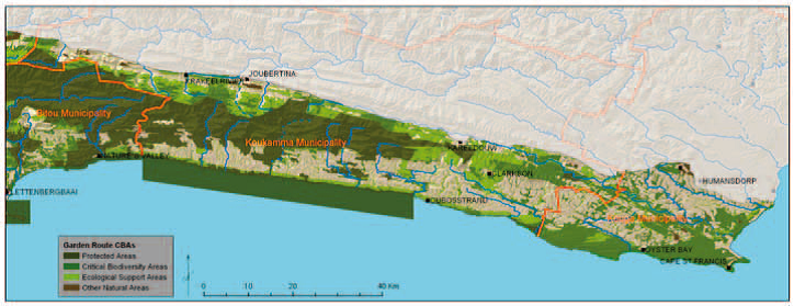
The Project Website summarizes its content as follows:
“The Critical Biodiversity Areas (CBA) map for the Garden Route Sector Plan (BSP) aims to guide sustainable development by providing a synthesis of biodiversity information to decision makers. It serves as the common reference for all multi-sectoral planning procedures, advising which areas can be lost to development, and which areas of critical biodiversity value and their support zones should be protected against any impacts. As part of the GRI and C.A.P.E. fine scale biodiversity planning, a systematic biodiversity assessment of the GRI was undertaken, and a critical biodiversity area (CBA) map was produced. This biodiversity assessment is used to inform Spatial Development Frameworks (SDFs), Biodiversity Sector plans, Environmental Management Frameworks (EMFs), Strategic Environmental Assessments (SEAs) and the Environmental Impact Assessment (EIA) process. This biodiversity assessment, through the development of a CBA map, is aimed at assisting biodiversity and land use managers and decision makers in this demanding task. This report summarizes the results of the biodiversity assessment conducted.” (see https://bgis.sanbi.org/GardenRoute/CBAs.asp [last visit: 08.05.202499])